[Date Prev] | [Thread Prev] | [Thread Next] | [Date Next] -- [Date Index] | [Thread Index] | [List Home]
Subject: RE: For the GIS SC - RE: First cut at a symbology use case - along with some other thoughts
Problem Statement: "When it comes to spatial information that is needed during a disaster, there is currently no consistent national set of map symbols available for the development of hazard and emergency management maps. In order to facilitate the exchange of information and data, to promote universal understanding of hazardous and vulnerable locations and to adequately address communication of mission critical information across agencies, jurisdictions, and all levels of public and private sectors, a set of standard cartographic symbols needs to be developed and endorsed by the Federal Geographic Data Committee (FGDC). The development of standards for hazard mapping will strengthen coordination and communication between planners and will enhance the ability of emergency managers to better understand information at a glance during crucial decision making moments."
Reworded as a Requirement: From an operational perspective, this problem can be re-stated in the form of a requirement: "There is a requirement to create a common operational picture. To build this operational picture, we need to access spatial and related content from many sources but be able to render (symbolize) them in a common consistent manner, independent of the data underlying feature classification scheme, structure or data model". These are my word.Leads to a simple use case:
I am an emergency management specialist. An emergency event has occurred in my area. The event is the release of toxic fumes from a chemical plant. I need to access spatial data from the city, the state, the USGS, and FEMA to create an operational picture using commonly known symbology - even though the spatial data are being accessed from multiple repositories. This operational picture must show streets, buildings, schools, hospitals, day care centers, assisted living centers, and other facilities that will require rapid evacuation. Most importantly, it must show a plume dispersion pattern. Once I create this operational picture, I need to broadcast it to the first responders using the same symbology and style, independent of the display device.
(Sorry if I mixed a few requirements in with the use case :-) )
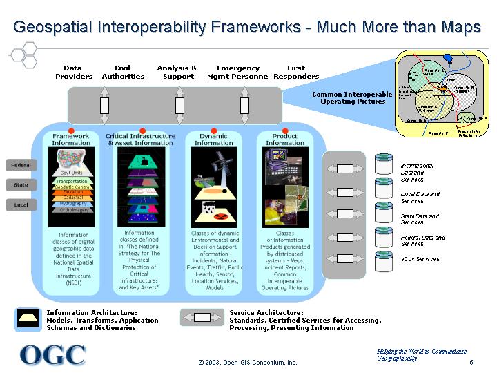
In picture form
The following picture depicts the realities of what an EM response team could deal with in terms of multi-source information access and fusion. Some content is static, some is dynamic. There are multiple jurisdictions. Each jurisdiction collects, manages, and symbolizes (portrays) their spatial data a bit differently. There is, therefore, an overarching requirement to provide the ability to utilize common symbology to enhance communication (by creating a common operating picture - or set of pictures). Much of the thinking that went into the following diagram resulted from a collaborative effort between the OGC, our members, and a number of local jurisdictions in an OGC Interoperability Project called CIPI - Critical Infrastructure Protection Initiative.
[Date Prev] | [Thread Prev] | [Thread Next] | [Date Next] -- [Date Index] | [Thread Index] | [List Home]