Not that we are ready to interact yet, but somewhere past ICAL
binding this comes into play
tc
"There are a thousand hacking at the branches of evil to
one who is striking at the root." -- David Thoreau
|
Toby Considine
Chair, OASIS oBIX TC
Facilities Technology Office
University of North Carolina
Chapel Hill, NC
|
|
Email: Toby.Considine@ unc.edu
Phone: (919)962-9073
http://www.oasis-open.org
http://www.NewDaedalus.com
|
From:
bounce-2021-435@lyris.nibs.org [mailto:bounce-2021-435@lyris.nibs.org] On
Behalf Of Deborah MacPherson
Sent: Wednesday, August 15, 2007 1:53 PM
To: fic-bim
Subject: Re: Diagrams - data migration
The following information is forwarded to
FIC-BIM from Matthew West Reference Data Architecture and Standards Manager at
Shell International Petroleum Company Limited, via Deborah MacPherson WDG
Architecture:
....talking about building requirements, we have a similar situation with
requirements for process plants. We have noticed several layers:
- Requirements specifications (what the customer wants)
- standard parts - parts defined by a publicly available standard, and
available competitively from multiple suppliers (e.g. nuts and bolts).
- Manufacturers models - manufacturers specifications for their products.
___________
Another piece of work I have done is ISO 18876 - Integration of industrial data
for exchange, access and sharing (IIDEAS). This is an architectural level
standard that shows what needs to be done to get different stuff to work
together (at the data level) so in principle, it would show how the SemWeb
stuff might be integrated with say a CORBA set up (if anyone still has that).
But as I say, it sticks to what is necessary for data integration.
___________
It seems to me that there are a couple of issues in what you are attempting
that need to be addressed.
1. You are dealing with geography/maps at a number of levels:
a) Identification by address.
b) Identification by coordinates (in some - not one - known coordinate
system)
c) What is there (e.g. a building), and spatial representation of that by
some local coordinate system.
etc.
How do you relate these to each other? How do you make this information
accessible to different applications (suggests some standards, or smart ways of
recognising the different forms of these).
2. What is the authoritative source for the information provided?
I think this is a much wider problem. One of the ways that we need to tame the
web is to understand who is the authoritative source for different sorts of
information. Ed Barkmeyer was talking yesterday about units of measure and
scales, and who is really responsible for those, but you have them being
provided here, there and everywhere without a link back to the authoritative
sources.
I think a key role that public bodies can play is to establish and encourage
authoritative sources, not least by recognising what information they are the
authoritative sources for, staking a claim for that, and recognising and
endorsing authoritative sources for other information they are not the source
for.
Anyway, my two cents worth.
Regards
Matthew West
Reference Data Architecture and Standards Manager
Shell International Petroleum Company Limited
Registered in England and Wales
Registered number: 621148
Registered office: Shell Centre, London SE1 7NA, United Kingdom
On 8/14/07 8:30 AM, "Louis Hecht" <lhecht@opengeospatial.org>
wrote:
Deborah
- Jeff provided you with some excellent, but early and notional examples of how
information models and ontologies might be utilized in AEC settings.
CEN, IAI and European Framework Programmes have certainly accomplished a good
deal of ground by tackling XML encodings, organizing data exchanges, and
exploring supply chain management. All of this previous work should be
considered by the US BIM community and I believe NBIMS is the place to do that
for the good of the greater community.
Alas, I know of no recent diagrams at a notional, informational, or systems
level that connects the dots between building information, modeling and
non-project-centric, life cycle overlaps and the layer cake diagram, W3
objectives, NBIMS scoping, independent BIM library building tasks, and Open
Geospatial Consortium work. Hopefully, through the combined and coordinated
work of BuildingSmart Alliance partners (both together and independently),
continuing advancements of NBIMS and international work we can have that
diagram available sooner rather than later.
Ontological capabilities remain rather immature at this time, and as you
rightly point out a number of information, communications and technology
community standards bodies like W3C and OASIS are hard at work in this area.
OGC is also hard at work on making geospatial information more ontologically
centric in tight coordination with W3C and OASIS and this includes a good deal
of information of considerable value to the BIM community.
However, I would like to address your questions regarding XML.
XML is for marking up data -- But XML is not intended to be read primarily by
humans and we should consider how such messages would appear to a machine,
which doesn't have our level of knowledge and understanding.
XML does not provide semantics. XML does not solve business problems.
XML Schemas do not provide semantics or solve business problems.
XML, by itself, does not solve interoperability problems, yet it is an
important tool for doing so.
Your question points to the relationship between all the standards that make up
the layer cake and the work so far accomplished by the AEC community which is
principally many flavors of XML. These flavors of XML cannot easily talk to one
another. When a receiving system receives an XML message, it has to do
something with it. It has to "parse" it and it has to "process
it". It does the former using generic software that merely understands the
structure and syntax. It does the latter by applying what is often
described as "business logic" or "business rules" to the
XML message and the data items within it, so that the data can be validated,
placed in appropriate locations for later processing, or shipped out to be
displayed or edited by the user on his/her desktop via a user interface, etc.
This business logic has to process the data in the messages according to their
meaning or semantics. This business logic must exist a priori - it must have
been created from some information architecture model that describes the domain
to which the message belongs. Currently that model is different for each
vendor, and non-interoperability is the result, but this can be resolved with
users and vendors working together in a neutral setting.
XML does not move nor become understandable without services, e.g, ftp or web
services, and here again those services remain largely within each vendor's
private domain. Additional work needs to be done isolate the necessary
functions of information systems that capture the advancements so far
accomplished by the AEC community using a service environment that rests on
standards based service interfaces. OGC is working to assist the AEC community
on the service interface development and testing side of things... Developing
open web services for building life cycle is needed and OGC's test bed
procedures are the proven, efficient way to develop interoperable web services
using the already developed flavors of AEC-related XMLs for the building life
cycle.
It would be great if the community can demonstrate its collective resolve and
the willingness to place resources behind the rhetoric and extend the XML
flavors that are developed with standards based web services that are also
within reach. A much fuller set of capabilities that approaches the NBIMS
mission will result for the market. Ontologies and AEC standards-based semantic
problem solving (also the province of standards bodies) will come more fluidly
after consensus is reached on standards-based information service
"architecture", and the diagrams you desire will be part of that
fabric.
While not a diagram per se, I hope this explanation makes a positive
contribution to yours and everyone's understanding.
LGH
Louis G. Hecht, Jr.
Open Geospatial Consortium, Inc.
------------------------------------------
Office: +1 301 365 5907
Cell: +1 301 792 1365
At 11:47 AM -0400 7/31/07, Deborah MacPherson wrote:
Dear
Dianne Davis,
Are the "DRAFT diagrams showing a change in information creation and BIM
development" available?
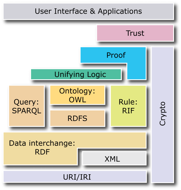
Have you seen the recent w3 layer cake diagram http://www.w3.org/2007/03/layerCake.png?
Ontolog and other forums are discussing, for example, positions of the proof
and logic boxes here [Message Archives: http://ontolog.cim3.net/forum/ontolog-forum/]
under "Current Semantic Web Layer Cake".
Where do you see realistic, non-project-centric, lifecycle overlaps between the
layer cake diagram, W3 objectives, NBIMS scoping, independent BIM library
building tasks, and open geospatial consortia? RDF and XML only?
Thank you,
Debbie MacPherson
--
Deborah MacPherson
Specifier CSI AIA
WDG Architecture PLLC
202 857 8300 x1184
www.wdgarch.com
--
Deborah MacPherson
Specifier CSI AIA
WDG Architecture PLLC
202 857 8300 x1184
www.wdgarch.com