United Kingdom
Delivering The
Digital National Framework in GML
DAVID
HOLLAND explains the whys and wherefores 
Ordnance Survey, Britain's national mapping agency, is transforming the way it operates in order to realise a new vision. The benefit to both existing and new users of geographic data will include a simpler pricing and licensing structure; a commitment to e-business and e-delivery; and a complete restructuring of the Ordnance Survey's core digital data.
Two of the key messages delivered by Vanessa Lawrence, Ordnance Survey's Director General, are that the organisation will be the data provider of choice for location-based services, and that it will develop as an e-business, readily embracing the products of the information age. The Digital National Framework (DNF), to be released to the public in November 2001, lies at the heart of this vision (visit http://www.ordnancesurvey.co.uk/dnf/home.htm for details).
When the DNF was under development, it became clear that existing methods of data supply (in NTF, a peculiarly British transfer format, usually on CD) were not in tune with this vision. As members of the OpenGIS Consortium, we followed the development of the Geography Markup Language (GML) with interest. This non-proprietary language is specifically designed to transfer spatial data over the Internet and it seemed an ideal solution to our requirements.
Perfect choice
Rather than wait for someone else to champion GML, Ordnance Survey decided to fully embrace GML and use it from the start. This presents a challenge in that we will be one of the first major users of a new technology that is still under development. However, this is outweighed by the many advantages that make it a perfect choice for DNF:
- It is not tied to any proprietary GIS or database software
- It is based on XML, the standard language of the Internet
- It is specifically designed for feature-based spatial data
- It is endorsed by the OpenGIS Consortium and its many members
- It is an open standard which anyone can use
The DNF data initially made available to users will consist of re-engineered large scale topographic data. Eventually, the DNF will encompass many other types of spatial information, such as smaller scale topographic data (ideally derived from the large scale data), imagery, transport networks, address information and height models.
|
 Each DNF feature (point, line and area) is labelled with a unique 16-digit number, known as a TOID, and has other attribute information attached to it. |
During 2000-2001, large scale data was transformed from a set of almost 230,000 tiles (conforming to a basic, unstructured point and line model) into a single, seamless topologically-structured point, line and polygon database. Represented in the database are buildings, roads and paths, administrative boundaries, railways, water features, and other topographic features. These are collected into themes (such as "buildings" and "roads, tracks and paths") from which users can extract data as required, either from a specific theme or group of themes.
Unique identifier
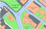
Each feature within the DNF is assigned a unique 16-digit "topographic identifier" (TOID) that can be used by Ordnance Survey or its customers to reference any given feature in the database. This will make it much easier for users to associate other information to the spatial feature; to refer unambiguously to a particular feature and, therefore, to share spatial information with other users. The screen shot illustrated overleaf shows an example of some DNF data, in this case a small area in the city of Exeter.
Ordnance Survey is working alongside several software vendors to ensure that their systems will be able to read, manage and process both DNF data and associated datasets when DNF is launched in November of this year. At that time, users will be able to order data online, choosing the themes they require for geographic areas of their choice.
Data will initially be supplied on
conventional media (CD & DVD) or via an ftp server. After receipt, users
will be able to query the DNF online, to determine any changes within their area
of interest. They will then be able to request all the features which have
changed since a given date. This will also be supplied either on CD, DVD or via
ftp. A full online supply service is scheduled for 2002.
Example of DNF data. This image was produced using the StruMap DNF viewer, developed by Geodesys. The viewer reads GML, extracts the features, and renders them according to their attributes (land in green, buildings in sand, roads in grey, etc).
In summary, the DNF provides a new framework for geospatial data in Great Britain. The restructured DNF data greatly enhances the versatility and usability of large scale topographic data, turning it from merely a "representation of a line map" into a GIS-friendly model of the real world. Using GML for data supply will make it accessible to more software systems, and hence to more users, than would be possible using any other single format.
DAVID HOLLAND is senior consultant in research studies with Ordnance Survey in Southampton, England, and can be contacted by email at: dholland@ordsvy.gov.uk
GML's Future
GML 2.0 is based on "XML Schema," an advanced XML standard that, in GML, enables the interchange of spatial information and the construction of distributed spatial relationships.
GML 3.0, begun at the Open GIS Consortium (OGC) meetings in Liege, Belgium in April 2001, will retain backwards compatibility with GML 2.0 and include support for some of the following: new geometry classes, events, histories and feature time stamps, units of measure, metadata, and coverages.
Universal system
Each professional subset of geodata producers and users employs a particular set of shared semantics. Data coordination - standardisation of feature semantics and metadata schemas in text files - proceeds apace around the world. GML provides a universal system for parsing such text, laying the foundation for previously impossible "intelligent" web-based spatial searches and semantic translations.
GML 2.0 is also well suited to the efficient delivery of small packets of geodata and dis-play instructions one reason why it is likely to find use in location-based services using location-aware, Internet-connected devices. OGC is working with the Location Interoperability Forum (LIF), Internet Engineering Task Force (IETF) and ISO/TC 204 to establish OpenGIS standards as an integral part of the infrastructure for such services.
European influence
OGC's upcoming OpenLS Initiative seeks to ensure that the standards these organisations adopt is consistent with OpenGIS Specifications. For the latter, OGC organises testbed and demonstration projects that enable "rapid prototyping" of the new specifications. As Europe leads in deploying wireless technologies, its location-based service providers will strongly influence whether or not simple location services can be well integrated - through OpenGIS Specifications - with more complex geodata and geoprocessing resources.