OASIS Mailing List ArchivesView the OASIS mailing list archive below
or browse/search using MarkMail.


Help: OASIS Mailing Lists Help | MarkMail Help

emergency message

[Date Prev] | [Thread Prev] | [Thread Next] | [Date Next] -- [Date Index] | [Thread Index] | [List Home]


Subject: RE: [emergency] Re: Circle and Polygon


The following is a note from the OGC Open Location Services Specification. This specification was developed by a group of GIS and non-GIS companies and location service providers from around the globe. It is starting to be used by Sprint, vodaphone, H3G, and other providers. Because, many times they are dealing with something as simple as a PDA or cell phone they have agreed to use WGS 84.
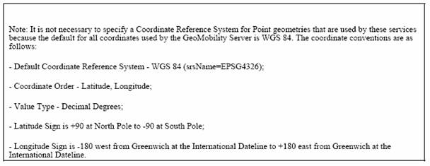


If it is determined that we need to handle alternative CRSs they should be handled as an exception rather than the default.


We should not invent yet another new way of handling these.

Attached are examples of a Simple Feature GML line feature (trail), point feature (utility), and polygon feature (inland water/lake). These are complete features with attributes, bounding envelop, etc. I think we would only be interested in the geometry making things much simpler.

The point is - note that the geometry Spatial Reference System (srs) is identified by the registry name (EPSG) and the item in the registry (the specific CRS – 4326)


Dave


David M. Danko

GIS Standards

Environmental Systems Research Institute, Inc.

8620 Westwood Center Drive

Vienna, VA 22182-2214

USA

E-mail: ddanko@esri.com

Tel: 703-506-9515 x 8011

Mobile: 703-989-1863

Fax: 703-506 9514


-----Original Message-----
From: Bullard, Claude L (Len) [mailto:len.bullard@intergraph.com]
Sent: Friday, June 17, 2005 4:01 PM
To: 'Art Botterell'; Emergency_Mgt_TC TC
Subject: RE: [emergency] Re: Circle and Polygon


While I am not personally acquainted with him,

Mr. Ianella is a TC member and has made very sharp

contributions to the TC work by my observation.


1. Regional data sharing systems developers cope

with legacy systems everyday.  WGS84 meets the

needs of the majority, but minorities are also

served by emergency systems.  Please respond

to the requirement to enable alternative CRSs

as needed.


2. Avoiding XML attributes is technically unsupported.


The first item is a requirement; the second, a means.

The choice of means is a choice of the TC.  IMO, the 

best choice is one that is technically reasonable and 

supports the requirements of the members regards their

local communities and the need for fast implementation.


I bristle when accusations are made that North

American opinions dominate OASIS designs; yet I am

more disturbed when member credentials are

questioned and their reasonable requirements are

dismissed as hypothesis.  It makes the accuser's case

and is itself, a position without merit.


len


From: Art Botterell [mailto:acb@incident.com]


On Jun 17, 2005, at 6/17/05 7:59 AM, Bullard, Claude L (Len) wrote:

> Why avoid attributes?  That is superstitious behavior.


Whether or not individuals share the theology, that's the choice the 

TC has made, repeatedly.  And I don't think the issue here is large 

enough to justify us going back and re-plowing that old and bloody 

ground.


> If you name it for it's origin, you will add hundreds of elements.

> If you codelist it, you only have to include that and maintain it.


See, this is where trying to compromise gets a guy. ;-)


Look, I remain persuaded that we can and should specify a single 

CRS.  I was merely trying to address a concern about the spec alone 

possibly not being enough to clarify which CRS that is.  I was NOT 

trying to open the door to forcing implementers to support hundreds 

of CRSs.


(At most they should have to deal with two... WGS84 and their 

preferred local CRS.  I suspect the vast majority will continue to 

get along just fine with WGS84 alone.)


Again, I haven't heard any actual implementer report any of this as a 

problem... nor have I heard any technical reason why it should one.  

This whole topic seems to be based on a hypothetical concern for some 

third parties' sensitivities.  Seems like we may be chasing ghosts here.


---------------------------------------------------------------------

To unsubscribe from this mail list, you must leave the OASIS TC that

generates this mail.  You may a link to this group and all your TCs in OASIS

at:

https://www.oasis-open.org/apps/org/workgroup/portal/my_workgroups.php


<?xml version="1.0" encoding="ISO-8859-1"?>
<wfs:FeatureCollection xmlns="http://www.cubewerx.com/cw";
   xmlns:cw="http://www.cubewerx.com/cw"; xmlns:wfs="http://www.opengis.net/wfs";
   xmlns:gml="http://www.opengis.net/gml";
   xmlns:xsi="http://www.w3.org/2001/XMLSchema-instance";
   xsi:schemaLocation="http://www.cubewerx.com/cw http://demo.cubewerx.com/demo/cubeserv/cubeserv.cgi?SERVICE=WFS&amp;DATASTORE=Foundation&amp;request=DescribeFeatureType&amp;outputFormat=GML3L0&amp;typeName=TRAILL_1M  http://www.opengis.net/wfs http://schemas.cubewerx.com/schemas/wfs/1.1.0/WFS-basic.xsd http://www.opengis.net/gml http://schemas.cubewerx.com/schemas/gml/3.0.1/base/feature.xsd";>
   <gml:boundedBy>
      <gml:Envelope srsName="EPSG:4326">
         <gml:coordinates>-179.999420,-47.162167 179.999900,77.223984 </gml:coordinates>
      </gml:Envelope>
   </gml:boundedBy>
   <gml:featureMember>
      <TRAILL_1M fid="TRAILL_1M.1013">
         <TRAILL_1M.GEOMETRY>
            <gml:LineString srsName="EPSG:4326">
               <gml:coordinates decimal="." cs="," ts=" ">102.756195068359,-2.62175011634827 102.757720947266,-2.62883329391479 102.764053344727,-2.65808343887329 102.763107299805,-2.67213892936707 102.758079528809,-2.68752789497375 102.759223937988,-2.69099998474121 102.763557434082,-2.69536113739014 102.765830993652,-2.707111120224 102.774276733398,-2.72091674804688 102.779975891113,-2.73380565643311 102.787414550781,-2.73808336257935 102.791641235352,-2.74049997329712 102.811058044434,-2.75824999809265 102.816749572754,-2.77274990081787 102.813529968262,-2.78908324241638 102.815803527832,-2.79461121559143 102.81925201416,-2.79622220993042</gml:coordinates>
            </gml:LineString>
         </TRAILL_1M.GEOMETRY>
         <TRAILL_1M.ID>845</TRAILL_1M.ID>
         <TRAILL_1M.F_CODE>AP050</TRAILL_1M.F_CODE>
         <TRAILL_1M.EXS>28</TRAILL_1M.EXS>
         <TRAILL_1M.TILE_ID>144</TRAILL_1M.TILE_ID>
         <TRAILL_1M.EDG_ID>934</TRAILL_1M.EDG_ID>
      </TRAILL_1M>
   </gml:featureMember>
</wfs:FeatureCollection>
<?xml version="1.0" encoding="ISO-8859-1"?>
<wfs:FeatureCollection xmlns="http://www.cubewerx.com/cw";
   xmlns:cw="http://www.cubewerx.com/cw"; xmlns:wfs="http://www.opengis.net/wfs";
   xmlns:gml="http://www.opengis.net/gml";
   xmlns:xsi="http://www.w3.org/2001/XMLSchema-instance";
   xsi:schemaLocation="http://www.cubewerx.com/cw http://demo.cubewerx.com/demo/cubeserv/cubeserv.cgi?SERVICE=WFS&amp;DATASTORE=Foundation&amp;request=DescribeFeatureType&amp;outputFormat=GML3L0&amp;typeName=UTILP_1M  http://www.opengis.net/wfs http://schemas.cubewerx.com/schemas/wfs/1.1.0/WFS-basic.xsd http://www.opengis.net/gml http://schemas.cubewerx.com/schemas/gml/3.0.1/base/feature.xsd";>
   <gml:boundedBy>
      <gml:Envelope srsName="EPSG:4326">
         <gml:coordinates>-66.878200,42.626600 -44.429300,53.851100 </gml:coordinates>
      </gml:Envelope>
   </gml:boundedBy>
   <gml:featureMember>
      <UTILP_1M fid="UTILP_1M.930.729030A9EC3A3A3A1F20020000">
         <UTILP_1M.GEOMETRY>
            <gml:Point srsName="EPSG:4326">
               <gml:coordinates decimal="." cs="," ts=" ">-55.8165664644912,47.9927902529016</gml:coordinates>
            </gml:Point>
         </UTILP_1M.GEOMETRY>
         <UTILP_1M.ID>67</UTILP_1M.ID>
         <UTILP_1M.F_CODE>AD010</UTILP_1M.F_CODE>
         <UTILP_1M.TXT>POWERHOUSE</UTILP_1M.TXT>
         <UTILP_1M.TILE_ID>118</UTILP_1M.TILE_ID>
         <UTILP_1M.END_ID>1</UTILP_1M.END_ID>
      </UTILP_1M>
   </gml:featureMember>
</wfs:FeatureCollection>
<?xml version="1.0" encoding="ISO-8859-1"?>
<wfs:FeatureCollection xmlns="http://www.cubewerx.com/cw";
   xmlns:cw="http://www.cubewerx.com/cw"; xmlns:wfs="http://www.opengis.net/wfs";
   xmlns:gml="http://www.opengis.net/gml";
   xmlns:xsi="http://www.w3.org/2001/XMLSchema-instance";
   xsi:schemaLocation="http://www.cubewerx.com/cw http://demo.cubewerx.com/demo/cubeserv/cubeserv.cgi?SERVICE=WFS&amp;DATASTORE=Foundation&amp;request=DescribeFeatureType&amp;outputFormat=GML3L0&amp;typeName=INWATERA_1M  http://www.opengis.net/wfs http://schemas.cubewerx.com/schemas/wfs/1.1.0/WFS-basic.xsd http://www.opengis.net/gml http://schemas.cubewerx.com/schemas/gml/3.0.1/base/feature.xsd";>
   <gml:boundedBy>
      <gml:Envelope srsName="EPSG:4326">
         <gml:coordinates>-179.999420,-70.917252 179.999900,83.575951 </gml:coordinates>
      </gml:Envelope>
   </gml:boundedBy>
   <gml:featureMember>
      <INWATERA_1M fid="INWATERA_1M.1013">
         <INWATERA_1M.GEOMETRY>
            <gml:Polygon srsName="EPSG:4326">
               <gml:exterior>
                  <gml:LinearRing srsName="EPSG:4326">
                     <gml:coordinates decimal="." cs="," ts=" ">119.593002319336,-31.6695003509522 119.595306396484,-31.6650276184082 119.600944519043,-31.6658897399902 119.603385925293,-31.669527053833 119.60050201416,-31.6739158630371 119.595664978027,-31.6728610992432 119.593002319336,-31.6695003509522</gml:coordinates>
                  </gml:LinearRing>
               </gml:exterior>
            </gml:Polygon>
         </INWATERA_1M.GEOMETRY>
         <INWATERA_1M.ID>28108</INWATERA_1M.ID>
         <INWATERA_1M.F_CODE>BH000</INWATERA_1M.F_CODE>
         <INWATERA_1M.HYC>6</INWATERA_1M.HYC>
         <INWATERA_1M.TILE_ID>177</INWATERA_1M.TILE_ID>
         <INWATERA_1M.FAC_ID>218</INWATERA_1M.FAC_ID>
      </INWATERA_1M>
   </gml:featureMember>
</wfs:FeatureCollection>


[Date Prev] | [Thread Prev] | [Thread Next] | [Date Next] -- [Date Index] | [Thread Index] | [List Home]